

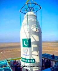
Historic moment as Pakistan places satellite in orbit
New satellite aids Pakistan in mapping land and risks
Pakistan-(Special Correspondent/Web desk) Pakistan’s modern remote sensing satellite has successfully entered orbit and established stable contact with ground stations. Officials confirmed that the satellite has started sending back high-resolution images of Earth, which will support projects like urban planning and infrastructure growth.
Boosting Disaster Monitoring and Relief
The new technology will improve Pakistan’s ability to track natural disasters such as floods, earthquakes, and landslides. This will make it possible to respond faster and carry out relief operations more effectively.
Protecting the Environment
According to Suparco, the satellite will support environmental monitoring by keeping an eye on glacial melt and deforestation. These insights will help Pakistan take stronger steps to protect the environment and manage natural resources.Kuwait announces extensive visa reforms
Supporting Farmers and Food Security
The satellite will also benefit agriculture by mapping crops and improving the use of water resources. With better planning and farming practices, it is expected to strengthen food security and boost overall agricultural output.
Strengthening CPEC Projects
In addition, the satellite will help identify geological risks and map important networks along routes connected to the China–Pakistan Economic Corridor (CPEC). This will make the projects safer and more sustainable in the long run.

Comments are closed, but trackbacks and pingbacks are open.